Survey Location
In this study, we selected those areas/districts/upazilas (sub-districts) as study areas from all administrative divisions to account for geographical variation, where a certain proportion of people belong to extreme poverty line (according to national poverty map by the world bank). We divided the areas/ regions into different small clusters. A cluster is a union/ ward in rural setting consisting of approximately 500 HHs (it could be a ward of the union or a portion of the union with approximately 500 HHs in rural setting and a slum-segment/ portion with approximately 100 HHs in urban slum setting). For rural clusters, we were expecting approximately 25-45% poor HHs (according to the national poverty rate in HIES 2016: poor if per capita expenditure per month belong to the upper poverty line of 2,268 BDT) in each cluster and hence approximately 125 poor HHs in each cluster.
The sample area was well distributed geographically to capture the selected marginalised groups under this survey. It covered all the administrative divisions (8), where 20 districts and 40 upazilas were brought under the survey. Under these 40 upazilas a total of 90 Mauzas/ Clusters were covered where we have got 50 unions, and 16 wards and 329 villages/ mohallas. The survey areas are shown in the Bangladesh Map.
Figure: Districts and upazilas under the survey (green) in the map of Bangladesh
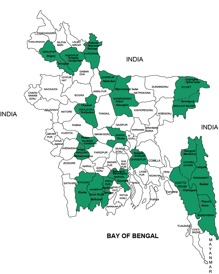
Table: Stratum specific sampling coverage area
| Strata | Sub-group | Communities | District/City corporation | Upazila | Union | Cluster* |
|---|---|---|---|---|---|---|
Ethnic/religion minority | Hilly Adivashi | Chakma Khyang Marma Tripura BAWM Khumi | Rangamati
| Langadu | Atarak Chara | 3 |
Barkul | Barkal | |||||
| Khagrachori | Ramgar | Thanchi | 3 | |||
Manikchori | Ruma | |||||
| Bandarban | Thanchi | Pathachhara | 3 | |||
Ruma | Manikchhari | |||||
| Plain land Adivashi | Garo Santal Hajong Monipuri Khashi | Sherpur | Nalitabari | Singra, Bulakipur | 2 | |
| Mymenshing | Haluahgat | Haluahgat, Gazir bhita | ||||
| Dinajpur | Ghoraghat | Singra, Bulakipur | 2 | |||
| Moulavibazar | Kamalganj | Adampur, Islampur | 2 | |||
| Sylhet | Gowanighat | Fatehpur, Tuker Bazar | 3 | |||
Sylhet Sadar | Khadimpara | |||||
| Religious minority | Hindu, Buddhist, Christian | Dinajpur | Ghoraghat | Singra, Bulakipur | 3 | |
Birganj | Mohammadpur, Mohanpur | |||||
| Chnadpur | Shahrasti | West Chitasi | 3 | |||
Hajigonj | Purba Barkul | |||||
| Shirajgonj | Chawali | Bagutia | 3 | |||
Shahjadpur | Gala | |||||
| Rajbari | Pangsha | Habaspur | 3 | |||
Goalanda | Daulatdia | |||||
Rural Poor | People with extreme poverty | Magura | Mohammadpur | Digha | 4 | |
Sreepur | Gayeshpur | |||||
| Barishal | Mahediganj | Alimabad Union | 5 | |||
Gaurnadi | Barthi Union | |||||
Bakergonj | Darial Union | |||||
| Rangpur | Taragonj | Alampur | 4 | |||
Gangachara | Barabil | |||||
| Kurigram | Fullbaria | Bara Bhita | 5 | |||
Nageshori | Ballabher Khas | |||||
Roumari | Bandaber | |||||
| Bagerhat | Sharankhola | Khontakata | 4 | |||
Mollarhat | Gangni | |||||
| Pirojpur | Kawkhali | Amrajuri Union | 4 | |||
Zianagar | Bali Para Union | |||||
| Mymenshing | Sadar | Akua | 4 | |||
Phulpur | Balia | |||||
Urban Poor | Slum-dwellers | Dhaka city corporation
| Korail slum (North) Duari Para (North) Mohammadpur slum (North) Lalbagh slum(South), City Palli (South) Driver colony (South) Rail-line Slum | 17 | ||
| Chittagong city corporation | Lalkhan bazar West Bakalia North Kattoli Enayet Bazar | 8 | ||||
| Khulna City Corporation | Ward 2: Ayjak jute mail, Mirer Dangha Ward 3: Amins quarter Ward 6: Kawser slum Ward7: North Kashipur, Nasir sheikh slum | 5 | ||||
*A cluster is the union/ward in a rural area consisting of approximately 500 HHs, and a segment/block of a slum in the slum territory of the city corporation, each consist of 100 HHs.